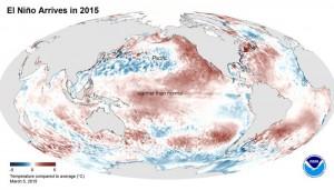
Basically, El Nino’s effects can be factored into forecasts…but it doesn’t create specific storms or day-to-day weather patterns. It only increases the likelihood of a breakdown in the eastern Pacific high-pressure system, which tends to guard the Central and SoCal coast from direct storm hits in winter. So increased snowfalls, increased bad coastal weather, increased swell are all more likely. But NOT certain to occur. Might add that the warmer water temps in the mid Pacific create a greater variance between the normal cold air sweeping down from the Arctic. The result? More convection, atmospheric turbulence, more wind. The storms all become more intense due to the extra warm air (from the warm water), which acts as fuel mixing with the cold air to create more of a combustible nature in the storms. Similar to Summer over the Great Plains in tornado season as all that warm moist air from the Gulf of Mexico moves up and collides with the cooler air sweeping down from the Plains. Equals greater thunderstorms and tornado development. With all this increased low pressure and combustibility in the Pacific, the jet stream drops further south resulting in a more southerly position of the storm track. That results in the storms having a direct hit on California (especially Southern California) while more northern areas like Oregon who usually get slammed have milder storm activity. The more southern storm track results in stronger storms closer to California which means bigger waves and more stormy conditions. More flooding and erosion along the coast. Also means more snowfall in the mountains. Hawaii is usually too stormy during El Nino years as the storm track drops down right on top of the Islands but which is great for Southern California. Regardless of all the above, El Nino, La Nina, whatever… one strong high-pressure system can ruin everything. High pressure often extends very high up into the atmosphere resulting in a very stubborn anchor, which may not be dislodged for 6-8 weeks or more. As the storm track and jet stream are forced to go around and over the top of the high pressure, the storms are too far away, too north, and aren’t able to generate the winds needed to send a good swell. If the timing in bad, say between January and March, one renegade high pressure system in the Gulf of Alaska can completely ruin a perfectly good California and Hawaii winter.